The problem
Voters want to know one thing: where can I go, and when? A map helps. But a map alone doesn’t work for someone using a screen reader, someone zooming in on a small phone, or someone who just wants to copy an address into their GPS. And when a site’s hours change, the map, the web page, and every social media post need to change the same day. Making each piece by hand, and keeping them all in sync, eats a morning you don’t have during early voting.
The prompts
Start in a folder
…\AI Projects\Early Voting Map\
Make the folder
On your C: drive, OneDrive, or an external drive. Your choice.
Open it in the app
Claude: Code tab → under the message box, choose Local → Open folder… ChatGPT: open Codex, click Add new project (or press Ctrl+O), then pick the folder. To add more folders later, open the project menu, choose Edit project, then Add folder.
Say what you want
Use the prompt below. Then open what it saved in the folder.
Say them out loud or type them. Change the words to fit your office. The AI goes and gets the public documents itself and saves what it makes in the folder.
Prompt 1 · Say it or type it
Build the list, map, and posts
Our approved list of early voting sites for the [Election name] is in this folder. Use it to make everything we need for our website and social media, and save it all in this folder.

Make a numbered list of the sites with name, address, dates, and hours (and drop box locations, if the list has them), plus a clean HTML version for our web page. Then make a simple map of [Your county] County with each site as a large numbered marker that matches the list. Build it from real GIS data, like the Census Bureau's TIGER/Line files for the county line and major roads. Make a 1080 by 1080 image for the website and a 1080 by 1350 one for Facebook and Instagram posts, with the title, the map date, and our website address on it.

Last, write alt text for the map that points people to the list, and a short social media caption. Copy names, addresses, and hours exactly as they are in the list, and tell me anything that's missing.
Fill in anything in [brackets] with your own details.
Already have a maps folder from the precinct maps use case? Do this there, so it reuses the same base map.
Prompt 2 · Say it or type it
Update when something changes
Site 3's hours changed to 9 a.m. to 6 p.m. Update everything that shows hours, including the images, and the map date, and tell me what you changed.
What you need
- The Claude desktop app (Code tab) or the ChatGPT desktop app (Codex) and a folder called something like
Early Voting Map. Put it on the C: drive, OneDrive, or an external drive. If you already have a maps folder from Precinct and polling place maps, use that one. - The approved list of sites, saved in the folder. Start from the list your office has officially designated, not a draft. If that list is already posted on your website, the link to the posted page works too: tell the AI to use it. Florida law requires the supervisor to designate early voting sites no later than the 30th day before an election and send the Division of Elections each site’s address and hours (s. 101.657(1)(b), F.S.). Drop box locations, which the law calls secure ballot intake stations, follow a similar 30-day rule (s. 101.69(2)(b), F.S.).
- The web address of your official list, so every map and post can point to it.
- QGIS (free), only if you want to fine-tune the map by hand.
Step by step
- Make the folder and save the approved list in it. If sites or hours are still being decided, wait.
- Open the folder in the app. In the Claude desktop app, open the Code tab, and in the row under the message box choose Local, then Open folder…. In the ChatGPT desktop app, open Codex, click Add new project (or press Ctrl+O), and pick the folder.
- Say the prompt. Change “early voting sites” to “drop boxes” or “polling places” if that’s the job.
- Open what it saved. Read the list line by line against the approved list. Read its note about anything missing, and fill those in.
- Look at every marker. This is where most map mistakes hide. You know where these buildings are, so a marker on the wrong side of town will jump out. For any that look off, open the address in your county’s GIS viewer.
- Have a second person review the images, the list, and the caption together.
- Post the image with its alt text, and put the text list right below it on the web page. On social media, put the link to the full list in the post text, not only on the image.
- When anything changes, say what changed (the second prompt is an example). The list, map, and caption update together. Ask for the time or a version number next to the map date, since hours can change twice in one day.
One possible outcome
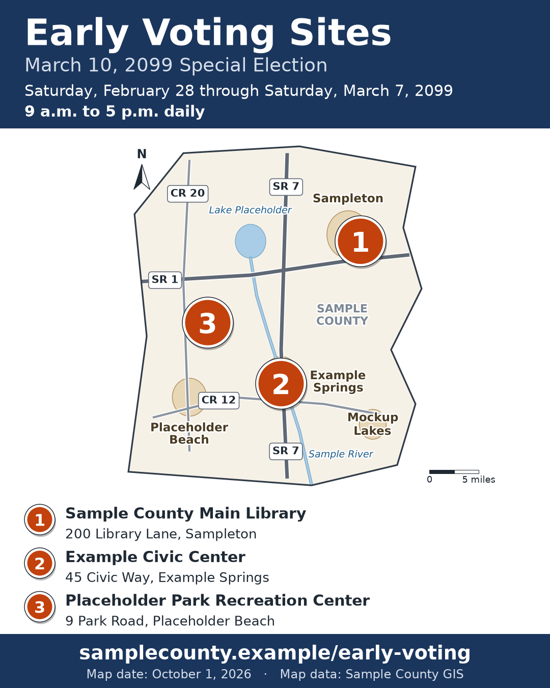
One run of the first prompt, with an approved list of three early voting sites and fictional map layers for a made-up Sample County.
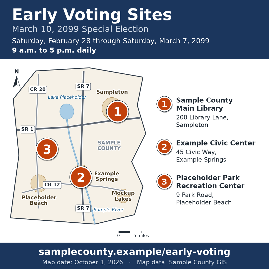 (opens the full version, PNG, 1080 × 1080, 215 KB)
Word, Excel, and PowerPoint files download to your phone; the PDF opens first. File names end in -DRAFT because AI output is a draft until a person checks it. Web addresses shown in these samples are made-up and will not open.
Make it yours
- Election Day polling places. Use the same steps with your polling place list. Link each voter to your precinct finder instead of listing every site in a social post.
- Drop box map. Put each location’s hours in the list. Drop boxes at your office and at early voting sites may have different hours.
- Ready for your website. Clean HTML for your CMS shows how to match the HTML list to your website’s format.
- Different platforms. One message, five platforms turns one caption into versions sized for each platform.
Time: by hand vs. with AI
By hand
2–3 hours
AI’s part, measured
About 25 minutes
in a test run of these prompts
With AI
45 minutes
your time, including review
About the measured time: “AI’s part” is how long the AI took, start to finish, in a test run of these prompts on September 27, 2026. It works on its own while you do something else. “By hand” and “With AI” are estimates of your own time.
Honest estimate. The AI builds the list, map, alt text, and caption in about 25 minutes. The rest is you checking every address, date, hour, and marker against the approved list and getting a second person to look. The first map takes longer if you don’t already have a maps folder.
Checking the work: what an expert looks for
You know this work, so you’re the best person to check it. Open every file it made and read every page. If part of it is outside what you know, hand that part to someone who knows it. These are the spots that most often need a fix:
- The text list is the accessible version of the map. Put it on the page as real text right below the image, not inside the image.
- Drop boxes that aren’t at a supervisor’s office can be used only during the county’s early voting hours (s. 101.69(2)(a), F.S.). A map or list without hours can send someone to a site that’s closed.
- Check each marker. Open the address in your county’s GIS viewer and make sure the marker is on the right building, not in the middle of the road.
- When a site or hours change, update the list, the map, and every post on the same day. The map date on the image makes old copies easy to spot.
- Never ask an image generator to ‘draw a map’ of your county. It invents streets and moves places around. The map has to come from real GIS data.
Last reviewed October 2, 2026.